
4 Hiking Trails - On Ons Island
On Ons Island, there are 4 different hiking trails you can go on. As mentioned before, there is very little elevation change on the island. The highest point is the lighthouse, which stands at an altitude of 128 m. This means that most of the trails are not difficult at all. Even so, if you decide to go on any of these trails in summer, it is important to always wear a cap, bring plenty of water and put on sunscreen. Due to the scarcity of trees on the island, you must take the necessary precautions to protect yourself from the sun and the wind.
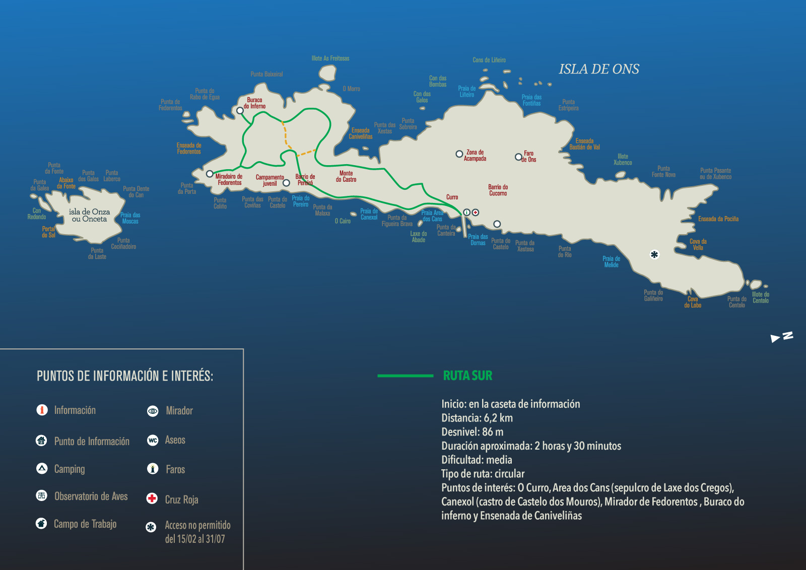

Southern Trail - Buraco do Inferno

- Distance: 6.2 km
- Estimated duration: 2 hours and 30 minutes
- Difficulty: moderate
- Format: circular
- Elevation change: 86 m
- Points of interest: The village of O Curro, Area dos Cans Beach, Canexol Beach, Fedorentos Lookout Point, Buraco do Inferno and Enseada de Caniveliñas.
Description of the trail:
The trail begins in the village of O Curro—the island's main village—, where you can find the main restaurants, the shop, the church and the interpretation centre. After leaving O Curro behind, go along a concrete path until you come to a crossroads. Take the diversion along the beaches to continue on the trail.
You’ll find Area dos Cans Beach on your left; it is one of the busiest beaches in summer. At low tide, you can easily reach the piece of stone known as A Laxe do Crego located in front of this beach. It is an anthropomorphic sarcophagus shrouded in legend.
Follow the path and you’ll get to Canexol Beach. Before going down to the beach, you’ll find an hórreo (stilt granary). On your right, you’ll find the old rectory house with the two largest hórreos on the island. If you look towards the small hill beside you, you’ll see the fort—without digging—known as O Castelo dos Mouros. Continue along the path to the last village on the island, Pereiró, passing by the youth camp of the Xunta de Galicia. By proceeding on your way towards the left, go towards the Fedorentos Lookout Point, where you will get a spectacular panoramic view of Onza Island, Ría de Pontevedra, Ría de Aldán, Costa da Vela, the Cíes Islands, etc. Stay on the path and you’ll get to Buraco do Inferno, a place shrouded in legend, where you’ll find a large furna (sea cave) with openings at the top. There are stories about a bull with golden horns guarding the entrance to Buraco do Inferno, which, as its name indicates, is the entrance to the underworld. Following the path, skirting the cliffs on the western coast, you’ll get to Enseada de Caniveliñas, where you’ll take a diversion to your right to return to the village of O Curro.
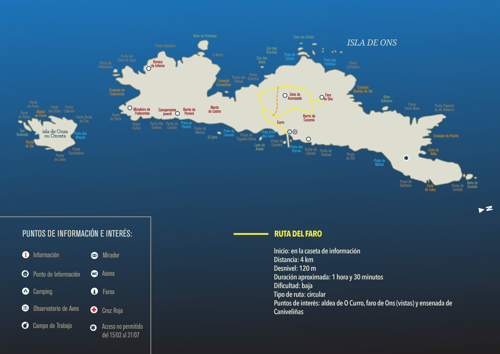
Lighthouse Trail
- Distance: 4 km
- Estimated duration: 1 hours and 30 minutes
- Difficulty: easy
- Format: circular
- Elevation change: 120 m
- Points of interest: The village of O Curro, the village of O Caño, the village of O Cucorno, views from the lighthouse and descent through the area of the cliffs.
Description of the trail:
The trail begins in the village of O Curro—the island's main village—, where you can find the main restaurants, the shop, the church and the interpretation centre.
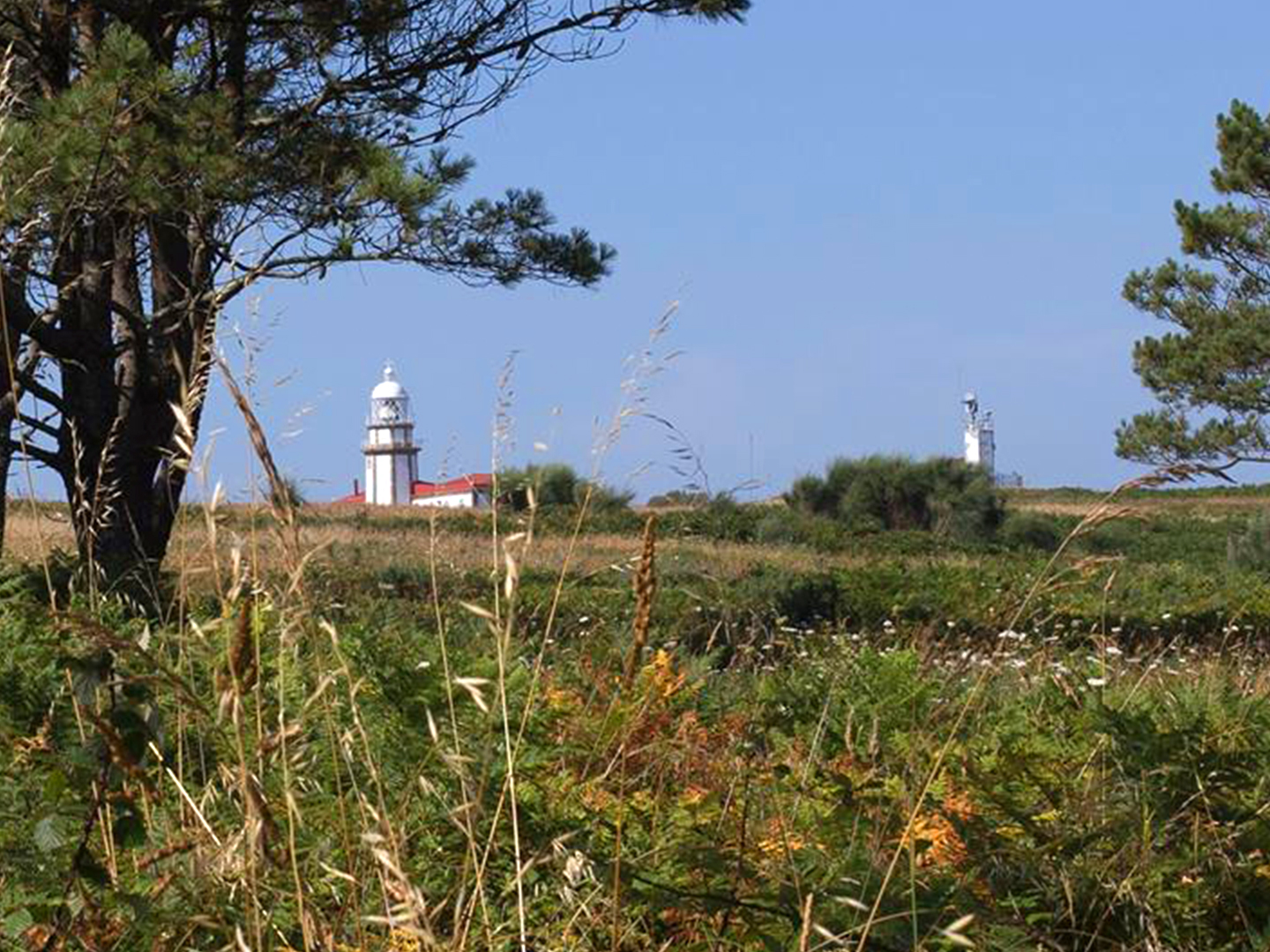
After leaving O Curro behind, go along a concrete path through the village of O Caño. You’ll see more of the island’s houses (with a nautical style), some washing areas, hórreos, etc. You’ll get to the village of O Cucorno, from where you can take in the views of the lovely Onza Island and Ría de Pontevedra. This lighthouse is one of the few remaining in Spain which continues to be manned by a lighthouse keeper.
Before arriving at the lighthouse, turn to the left. By bordering the lighthouse, you’ll get wonderful views of Ría de Arousa, Sanxenxo, A Lanzada Beach, Sálvora Island, etc. Following the path, you’ll reach the heliport. Take the path going down to your right. Skirt the cliffs and marvel at the immensity of the Atlantic Ocean as you walk back to your starting point.
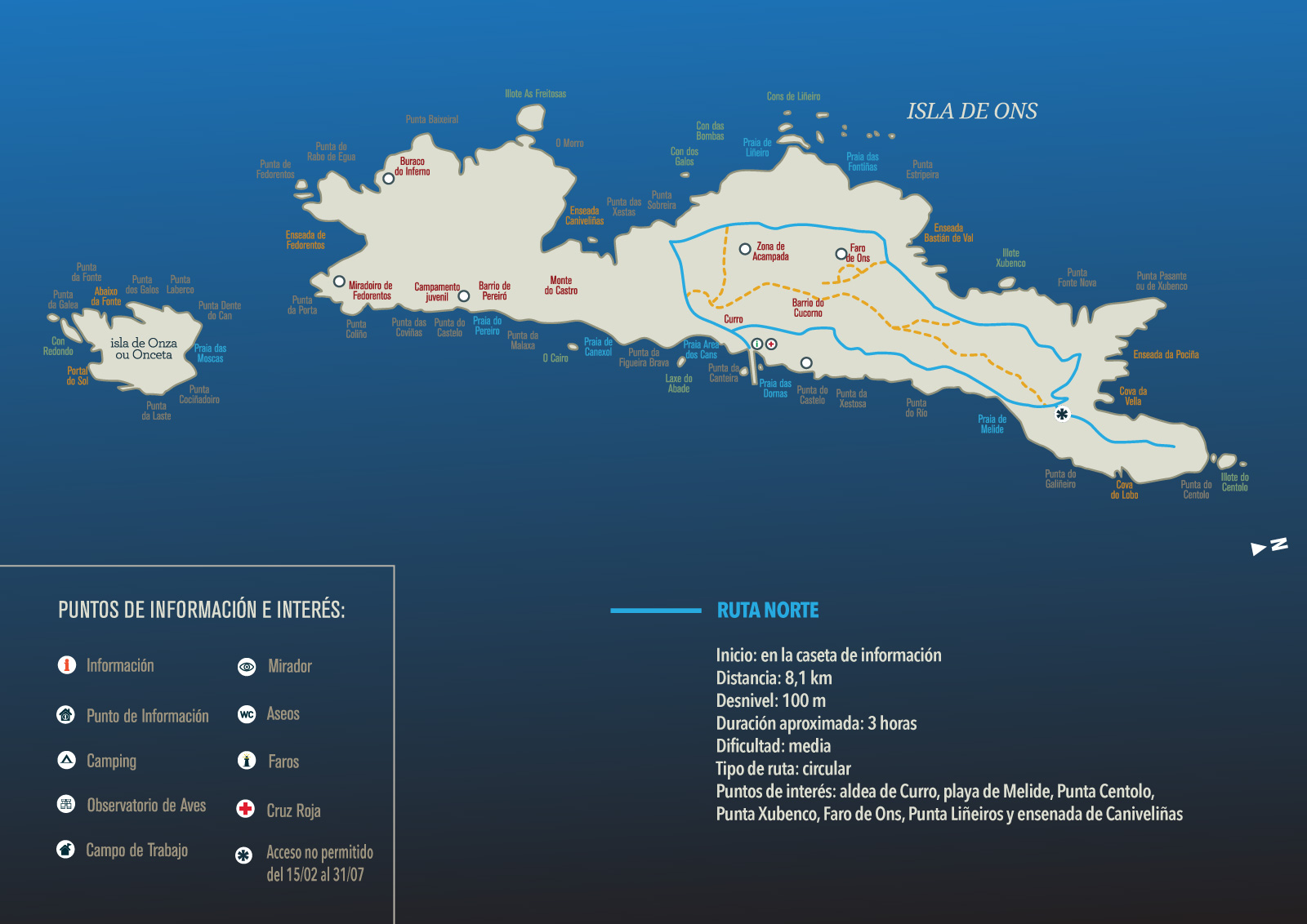
Northern Trail - Melide Beach

- Distance: 8.1 km
- Estimated duration: 3 hours
- Difficulty: moderate
- Format: circular
- Elevation change: 100 m
- Points of interest: The village of O Curro, Melide Beach, Punta Centulo, Punta Xubenco, Ons Lighthouse, Punta Liñeiros and Enseada de Caniveliñas.
Description of the trail:
The trail begins in the village of O Curro—the island's main village—, where you can find the main restaurants, the shop, the church and the interpretation centre. Take the path to the right side of the church. Walk along some paths amidst the vegetation you’ll find throughout the entire trail.
Continue with the trail, passing Fonte do Castelo and, after taking the path to the right, it will skirt the gentle cliffs on the eastern coast until Melide beach (the nudist beach on Ons Island, a beach of outstanding beauty, which is definitely worth a visit). From here, climb up to the crossroads, choose the right and take the diversion to the Punta Centulo Lookout Point, which has restricted access between 15 February and 31 July (as it is a breeding area).
After getting back on the path, continue southwest along the steep western coast—between Punta Xobenco and Punta Liñeiros—, a great place to go birdwatching and observe their nesting areas. After descending towards Enseada de Caniveliñas, turn left and cross the island on your way to O Curro.
Castelo Trail

- Distance: 1.1 km
- Estimated duration: 40 minutes
- Difficulty: moderate
- Format: circular
- Elevation change: 33 m
- Points of interest: As Dornas beach and Castelo Lookout Point.
Description of the trail:
The Castelo Trail is the shortest route on the island, running a little over a kilometre, following the path near the sea. It starts beside the pier, passing by the small As Dornas Beach, which gets its name from the traditional fishing boats used by the islanders and which can be seen on the beach today.
From here, go north, crossing the feeding area. You’ll enter a small willow forest and finally arrive at the Castelo Lookout Point, from where you have a panoramic view of the estuary and the Ons pier. You’ll return to O Curro along an inland path away from the sea, by going south.